September 19, 2019 3:31 pm
Tropical Storm Imelda was the fourth-wettest storm on record in the state of Texas, causing devastating and record-breaking floods in southeast Texas. The eleventh tropical storm and ninth named storm of the 2019 Atlantic hurricane season, Imelda formed out of an upper-level low that developed in the Gulf of Mexico and moved westward. Little development occurred until the system was near the Texas coastline, where it rapidly developed into a tropical storm before moving ashore shortly afterward on September 17. Imelda weakened after landfall, but continued bringing large amounts of flooding rain to Texas and Louisiana, before dissipating on September 21.
Impacts began when Imelda made landfall as a weak tropical storm. The system brought heavy rain and dangerous flooding to parts of southeastern Texas (especially the cities of Galveston and Beaumont) as its motion gradually slowed over land. Dozens of water rescues were needed by September 19 as areas became overwhelmed by the rainfall, with some areas experiencing over 43 inches (1,100 mm) of rain. Total damage is estimated in excess of $5 billion (2019 USD). Despite the storm causing substantial damage, the name Imelda was not retired following the season, making Imelda the second-costliest Atlantic tropical storm name on record to not be retired, with the costliest being Hurricane Sally the following year.
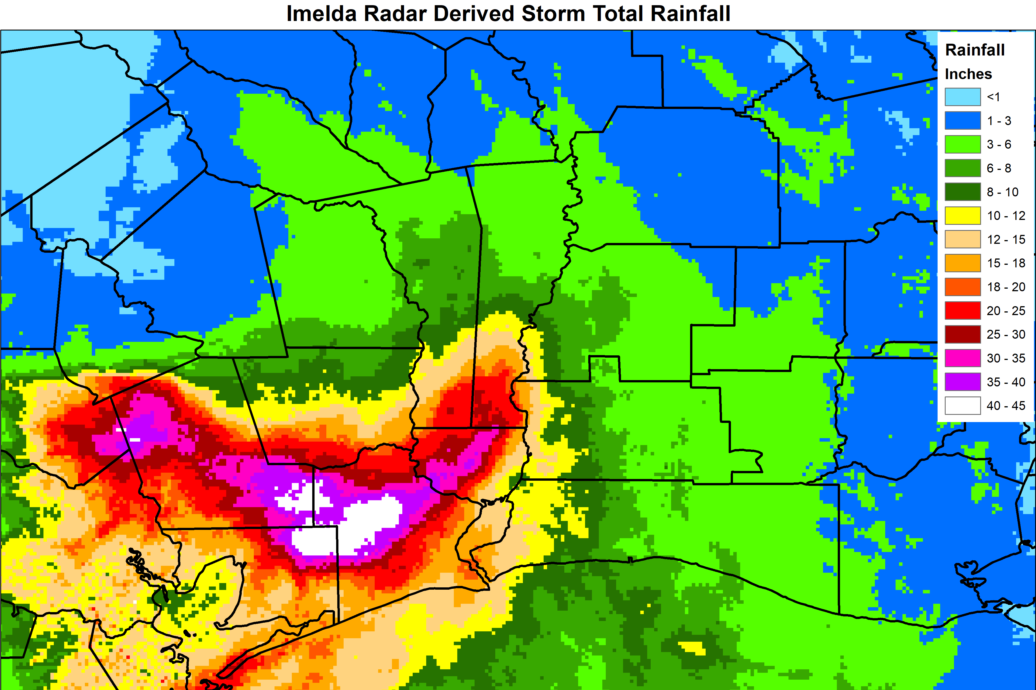
Imelda’s slow movement over Southeast Texas and a continuous influx of tropical moisture led to copious amounts of rainfall over the region. This moisture supported the formation of rainbands that repeatedly moved across the same areas of Southeast Texas between September 17–19. Several counties spanning parts of the Greater Houston metropolitan area and Beaumont, Texas, recorded over 30 in (760 mm) of rain. A maximum rainfall total of 44.29 in (1,125 mm) was documented at a station 2 mi (3.2 km) south-southwest of Fannett, Texas; this made Imelda the seventh-wettest tropical cyclone in U.S. history, fifth-wettest in the contiguous U.S., and fourth-wettest in Texas history. The same station recorded 31 in (790 mm) of rain in 12 hours. Rain fell at over 5 in (130 mm) per hour in several places. Flood depths in some locations exceeded those recorded in Hurricane Harvey due to the high rainfall rates. Where rainfall was heaviest, the rainfall total represented a 1-in-1000-year rainfall event. Destructive flooding occurred along Interstate 10 between Winnie and Orange, Texas, where over 42 in (1,100 mm) of rain fell. Over one thousand vehicles were caught in flood waters. Many homes and businesses were also flooded, resulting in numerous high-water rescues. Approximately 8,200 homes were flooded in Harris, Jefferson, Liberty, and Montgomery counties in Texas. Five deaths were directly attributed to the floods, of which three occurred in Jefferson, while two occurred in Harris County. The National Centers for Environmental Information estimated Imelda inflicted $5 billion in damage.
Jefferson County, Texas, was the county most heavily impacted by Imelda. An estimated 5,100 homes were flooded in the county, suffering $14 million in damage. Major street flooding occurred in Beaumont where the Jefferson County flooding first began. Over 38 inches (97 cm) of rain fell in the city. Encroaching floodwaters prompted the evacuation of Riceland Medical Center in Chambers County, Texas. Stream flooding persisted for days in Hardin County, Texas, where 10–40 in (250–1,020 mm) of rain was measured. Many buildings and roads were rendered impassable. Sixty homes were flooded in the county, resulting in $2.3 million in damage. In Orange County, Texas, Imelda flooded 2,679 homes, resulting in $12 million in damage. Near Mauriceville, Cow Bayou reached its second-highest crest on record. In Jasper and Newton counties in Texas, an estimated $2.4 million in damage was incurred following the flooding of 15 homes.